
Fieldbot has pioneered a new perimeter early-detection system.
The next frontier in smart agriculture isn’t just across the field. It’s above the crop canopy.
Remote sensing is now the pivot point—literally and narratively—from universal precision upgrades to a scalable Physical AI infrastructure layer.
For economical full-season crop sensing, every UltraCore™-upgraded irrigation pivot brings together four essential infrastructure capabilities: onboard electric power, an elevated structure directly above the crop canopy, space-based cloud connectivity, and precisely controlled UltraFast™ machine mobility—providing a scalable, continuously connected platform for high-resolution autonomous crop imaging, persistent agronomic observation, and increasingly intelligent, data-driven autonomous crop management.
Rather than merely irrigating, fertigating, and chemigating crops at field scale, every UltraCore™-upgraded irrigation pivot also becomes a giant data-harvesting robot—persistent physical infrastructure that continuously generates and aggregates diverse, full-season, high-fidelity proprietary intervention-and-response datasets with exceptional spatial and temporal resolution at unprecedented velocity, scale, and economic efficiency.
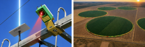
Operating continuously throughout the entire growing season while orbiting directly above the crop canopy, an UltraCore™-upgraded irrigation pivot, equipped as standard with a single camera module at the outer end of the machine, can autonomously capture high-resolution multispectral crop imagery—scanning approximately 2.8 acres along the field perimeter per imaging pass for early detection of crop stress, disease, insect pressure, and other adverse agronomic conditions—while the same all-in-one agronomic machine platform simultaneously records every application of water, fertilizers, and crop protection products, including what was applied, when it was applied, and how the crop responded biologically to each intervention over time.
Daily, UltraFast™ Constant Move “non-irrigation passes”—completed in just 90 minutes to minimize disruption to irrigation schedules and regularly scheduled at the hottest time of day, when water-use efficiency (WUE) is at its lowest—unlock autonomous crop imaging that produces a novel, full-season visual record of the crop’s growth, stress, and biological response to agronomic interventions.
Fieldbot uploads high-resolution multispectral crop imagery autonomously captured by on-pivot Sentera Field Vision remote-sensing systems—GPS-enabled and connected to the cloud via Starlink—to the Sentera FieldAgent™ data analytics platform, which produces increasingly intelligent, actionable agronomic insights and data-driven recommendations over time.
In addition, and for the first time, this continuous stream of imagery creates a longitudinal understanding of crop development across the entire growing season, from germination through senescence, at near-zero marginal cost.
These same high-resolution images enable Fieldbot to continuously generate and aggregate diverse, full-season, high-fidelity proprietary intervention-and-response datasets at unprecedented velocity, scale, and economic efficiency.
By correlating every agronomic intervention with measured biological crop responses, Fieldbot creates a uniquely differentiated, scalable Physical AI infrastructure layer for continuously advancing increasingly capable, self-improving agronomic intelligence and autonomous crop management—the foundation for agricultural AI.